28.7.12

landscape photography and surveillance

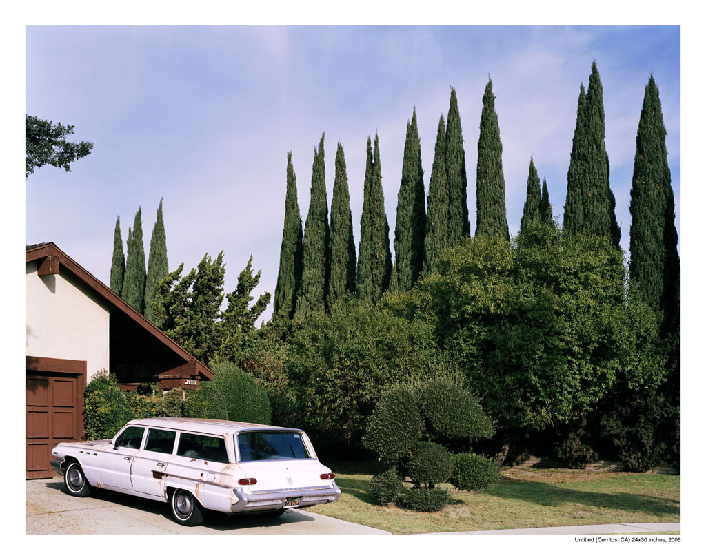
The border of an image I had downloaded contains the information Untitled (Cerritos, CA) 24x30 inches 2006.


The photo made a single web appearance and is not included on the photographer's site. They are quite distinctive trees so I paid a visit to Cerritos in Google Satellite and was lucky enough to spot them fairly quickly. They screen off what appears to be a single track railway.


The photo is dated 2006. In Streetview (which didn't start until 2007) the same clapped-out car still occupies the driveway, through which we can infer that the owner rarely uses his garage and hadn't updated to a more recent model.


A fascination with film locations attracts fans as though they might recover something of the mythic world of cinema from the actual site extends to photography where you might want to visit the location represented in an iconic image.  Because Google's automated image gathering is indiscriminate and the encompassing image is traversable it assumes the aura of a reality itself. The photographic moment is preceded and succeeded by the Streetview panorama. The reality principle is absorbed into an encompassing and compelling panoramic simulation that adds another layer to the construct of a landscape photograph.Through this technology the viewer is constituted as a stalker or detective in an attempt to puncture the fiction of the photograph and regain the referent lurking within - only to discover another level of representation.

This assumption of reality is the rehearsal for extending the corporate project even further into every aspect of space and the fabric of the world. With nanotechnology this penetration could link with GPS to cocacola-ise everything from the atomic scale upwards. When Jordan Crandall talks about cinema as a form of tracking,  landscape photography as an act of collusion with the new total surveillance technologies courtesy of Google becomes eerily apparant. Recently the fugitive John McAfee was tracked to his Guatemalan hideaway by information encoded in an  Jpeg uploaded onto the Web.

A recent article reviews photographers using images captured directly from Streetview as their work
http://www.guardian.co.uk/artanddesign/2012/jul/14/google-muse-street-photographers-interviews
http://www.guardian.co.uk/artanddesign/2012/jul/14/google-street-view-new-photography

Their work raises interesting questions about the photographer and their relation to subject and audience, a point acknowledged by Doug Rickard whose project A New American Picture tips a nod to Robert Frank's book The Americans. Sitting at his computer and trawling Streetview for dystopic American scenes he cites Bresson's decisive moment as being instrumental to his method where his images are a conscious mythic construct achieved by singular framing and editing, an aesthetic layering that takes the work away from documetary https://vimeo.com/30357393. He prefers the older less sharp images of the older Streetview cameras and excludes any of the onscreen tool icons. His work consciously addresses the power of photography to form mythic images. Streetview itself, due to its ongoing updates, has the means to deconstruct this formula. In this updated image American Collision is getting a makeover.


Here it is fairly easy to track the image through a web search of the name of the business.

Google, for reasons best known to themselves, aren't above doing their own editing.


This image captured by Jon Rafman has been subsequently blurred from all angles.


The gritty scene of urban decline and the implied violence of a torched vehicle is suspended within a wider context that speaks of a safer environment than the one suggested. It is the Google car itself, which has to mount the pavement to get by the traffic backed up behind the burning camper and again to pass the fire truck attending the blaze, that is the only lawless element here.


I found another blurred out element as I was noding (panorama hopping in Streetview) around the London Olympic site.


Another example of editing is the complete removal of an panorama or a series of panoramas that offends the Google sense of propriety, such as dead animals and people. In this case the only drama is of the camera finding itself among the branches of an overhanging tree. Now only a vestigal branch suspended in space remains from that event.




15.1.12

reciprocal assymetry


I did a search on Youtube to see if there were any videos of the Streetview car and sure enough there was quite a crop. Seth38101 picks the car up at where Point Drive meets the US 220. He prefaces his shot of the car with an anecdote about having recently blogged his desire to be a Streetview driver and his weird luck at actually having encountered the cat itself http://www.youtube.com/watch?v=gv_tHubgYY0. The first view in the video of the Google car is shot here (38.958297,-79.159091) in the scene below.


The Google car is following a car transporter and this three vehicle convoy continues up the road for a while with Seth38101 keeping his distance so as not to spoil the Streetview shots, he says. He muses that he might flag down the driver and ask him how he got the job but notices his fuel is getting low and overtakes and parks up ahead at the Bethel Church of the Brethren http://bethelchurchofthebrethren.com/. There he gets his final shots of the transporter and Google car as they pass. He also includes the sign outside the church that is visible in Streetview and in a legible version on the church website.


The Streetview camera freezes in a series of panoramas the moment when the red Jeep (which appears in another of Seth38101’s videos) overtakes the Google car and its final appearance further up the road outside the church.


The video is a real time version of the event albeit with edits. The relative quality of the images from the video shot on an iPhone and the Streetview camera hold some fascination but the viewer may also jump from node to node in Streetview comparing scenes to the video knowing that both are a simultaneous record of the day. The video is zoomed in which compresses the space while the Streetview camera is a wide angle composite. Here sunlight flashes off the screen of an oncoming car in both Streetview and Seth's video:


 Here some glitch in Streetview causes a blue stripe to become part of the visual experience:


Each panoramic node of Streetview is experienced in real time as the viewer pans around it. In terms of the events of this narrative, travelling north up the US220 will take the viewer back in time to a point before the red jeep comes into view. From each node one can pan about within the span of their journey together to see the car transporter in front and Seth38101’s Jeep following behind.

As Youtube are owned by Google, all these experiences come courtesy of their corporate beneficence. Encountering the Google car confers the possibility that your image will be transposed from the sub-lunary world to Streetview (until the next update) to partake of a form of ecstatic electronic fame within a panorama or panoramas viewable by millions if you aren't comletely blurred out and edited.  

Google hosts the viewer recording their survey in an economy of mirrored surveillance and fervent mutual promotion. It is worth noting that, until recently, it is the car that determines the scope of the survey with the user of Streetview as a special case of passenger, the computer monitor standing in for the windscreen and the engagement with the environment being as distanced as the occupant of a car. Movement between the Streetview panoramas remains as jerky as a learner driver but without the same danger of collision. Now tricycles are used instead, extending the possibilities beyond the street.
This video shows the Strretview car with its camera hooded
http://www.youtube.com/watch?v=1i1G2iIwNjs and by posting the video the filmmaker becomes Google information without the camera having actually filmed them.
Two videos that attest to the compelling allure of the Streetview world.
Baudrillard’s essay on the ecstasy of communication:
http://199.91.152.155/b9t87b6lxxgg/1kgz54acgn0u2km/Baudrillard+Ecstasy+of+Communication.pdf

I found the video on Youtube and noticed the sign marked 220 that I assumed was the road number. Seth38101's location is on his Youtube channel and it only took a few minutes to find the church with his red 4x4 parked outside, the same vehicle that he had described in the introduction video to his new house. That felt as thrilling as any more meaningful investigation and I think that thrilll has something to do with the compelling power that the blanket representation of Streetview offers, the sense of the world being valorised by an impartial authority. The query I had posited was closed by this recripocal evidence. There is something here of the compulsion to visit film locations or even archaeological sites - to be at the site of a mythic occurance. Streetview engenders surveillance, tracking, and detection narratives.

In this case I was witnessing too the charm of the reciprocal gaze, from the vicarious pleasure of pursuing the Google car through Seth38101's video to the irrefutable objectivity of the presentation of his jeep and further up the road the car transporter by the Google camera. From slight clues it was possible to ascertain from my desk the location of that particular video event which itself is a powerful capability. It is similarly possible to view in Streetview, for example, the exact spot where the couple in the "Vancouver Kiss" photo were located from the information in the photograph and from two videos posted on Youtube shot from a carpark above the riot.

I located the church but my firewall closed my browser window and it took a further 3/4 of an hour torediscover it. 

The church site quotes from I Corinthians 13:1


9.7.11

First and Last

Seems the First and Last Inn is proving difficult to leave so this journey will continue as a pub conversation.

An associate I know (Mocksim) was in Arles which is where I mistakenly thought Van Gogh died. I asked him to take a picture of a sign that I had once seen in a documentary placed in the field whereVan Gogh shot himself . A little research and it turns out that Van Gogh died in Auvers sur L'Oise which is north of Paris so I went trawling in Streetview for images. I found this video on Youtube: http://www.youtube.com/watch?v=9yWEDFdddXs a walk through the fields to the place. Streetview can't go there but some images have been posted of which this is one. The sign depicts a painting presumably where it was made and perhaps  where Van Gogh shot himself.


The path followed in the video is very clear in the satellite picture and the particular tree in the video can be referenced with the ones taken from the satellite. It's even possible to see the sign with the patch of earth worn bare by the feet of visitors. At one point the video pans to the right and it is possible to see the cemetary where Van Gogh and his brother are buried, a corner of a foreign field that is for ever The Netherlands.


The sign can be seen in Streetview from the road near the cemetary looking towards trees that I imagine contain a rookery where the crows nest.


However the sign in the field isn't unique and they are scattered about Auvers each at a spot where a painting was made.These can be seen in Streetview either directly as below or in photos uploaded.

Here is one at the church.

There is a striking correlation of virtualities between a town imaging itself so thoroughly through paintings and its presence in Streetview. In the same way as the world can now only exist in reference to Streetview, Auvers can only be seen through a set of temporal and spatial displacements between the absent paintings and the restoration to their site of origin through these signs. There is something Ballardian and chilling in their totalising vision being so widely cast in real space. A church clock stuck at ten to three morphs into a reproduction of a whirling eye from the nineteenth century. The painting itself in Paris spawns a penumbra of fridge magnets, mugs and tea towels that swarm north to the town. In Auvers the whole place is in danger of foundering in time through these shuddering portals. The sense of otherness engendered by the art object collapses and its hard won relationship with the world is betrayed. The only redemption now is an app (http://www.guardian.co.uk/media/2011/jul/06/afghanistan-war-iphone-images?INTCMP=SRCH) that will turn your photos into Van Goghs.

I HAVE NEVER BEEN TO AUVERS

I HAVE NEVER BEEN TO ST JUST

The floors creak here in The First and Last Inn and I try to wake from that dream of being trapped in fishing nets and a rising night tide. The phantom of Annie George breathes her memories into the heads of sleepers.


14.2.11

Cov


At Coventry a railing reshaped by a car fender simultaneously forever pristine.  The evoked Ballardian fetish impact unwinds as time reverses between two images.


The bird feeder moves away in Streetview and the birds flock down to feed in my photo behind the twisted railings.


The turf that clothes the bankings we will have sped by in the rain on the journey south, too quick for a photo but slow enough for memory, retains a brick like pattern - a wall of grass - that may one day fade into a continuous steep lawn against the honeycomb of concrete slabs.

2.2.11

farewell lands end

The plummet from a satellite image into a prisitine landscape. The body has taken the form of a yellow figure standing on a green pointer. The man who fell to land's end.

There may be evidence that country smells might once have existed - flowers or the smell of manure. What blooms in the hedgerows of Streetview? The left fork beckons and the landscape blurs between each hyperlink.


The car that was ahead has vanished and more horses have appeared in the field a sign possibly of mysteron activity. A lovely sunny day and  flowers blooming in the verge.  A pink interloper marked with an A. A potential starting marker ready to burst with seeds of information that would have already determined a potential B.


A totem guards what appears to be convincing piles of horse shit in the field. I can't quite shift position in streetview to get the clear plane of the field behind the subject instead of the horse's arse. but maybe an engine of country smells and its guardian should be conjoined


Sentinals are placed along the entire field. They are silent and no rollover springs up when the cursor passes them. They retain their secrets - black holes of data.


Passing the mobile home site I am reminded of the book Red Shift where the main characters are trapped in time loops forever replaying variations of their own histories.


Looking back from the Sea View holiday park the sea is a blue signal from itself squeezed between the sky and distant fields.

Sennen and the First and Last Inn gets in the spirit of the quantum zeitgeist. I fire off an email in the hope of some interaction.

hi daphne

a couple of so called artist types are passing your way over the next few days imagining ourselves as a kind of withnail and i combo. we are generally harmless but wondered what kind of welcome to expect? lurid images of werewolves or homicidal villagers gleaned from films crowd our minds and to be honest we would probably prefer brusque than anything mary portas might endorse. not that we are lacking in courtesy or civilised ways ourselves. we are also taken by the heavenly overtones of the pub's name he who shall be last shall be first and vice versa as the good book says. let's hope that doesn't refer to getting served (just kidding)! we're fans of live music and lively conversation.

in google streetview there are a couple of shady characters in high vis (if that is possible) walking by the side of the pub and we wondered who they might be.

yours,

mike and huw

But no reply not too surprisingly. As is somehow to be expected the sign is different depending on which way you approach it.
Unexpectedly the First and Last pub sign is on the event horizon of two stitched panoramas - a kind of Streetview joke - and is beginning to vanish like the fading smile of a Cheshire cat. Two reality bureaucrats enter from another world with compact monitoring equipment.

1.2.11

divertimento

On 27.01.11 I was on a rail replacement bus from Haywards Heath to Three Bridges. At 13.25 according to the enbedded info in the jpeg file I took this photograph from the upper deck.


I was trying to take a row of traffic cones but ended up with one due to the delay with focusing and metering. As it transpired my picture was taken from almost the same point as the one taken by the Streetview car - at the same node.

The traffic cones were a temporal event in the scene that provided a kind of reference between the world and Streetview. Would the cones be there in Streetview when I checked later so that these transient monuments might atain a degree of permanence?


A photograph once had a more or less indexical relation to the world with an image being a frozen moment of a mostly unrecoverable reality. The world extends away in all directions and is capable of being traversed and returned to. A photograph cannot be physically entered and essentially remains materially unchanged on subsequent visits. It exists within the world.

Streetview is a special case of panoramic photograph that gives the illusion of being entered and traversed.

Since Streetview neither the photograph or the world can exist, either independently or with relation to one another. The indiscriminate nature of the image harvest and the extensivity of the  project approximates to the world to the extent of being a form of reality to be entered. Now the world is no longer the sole signified and the landscape photograph only exists after Streetview as secondary deja vu phantom. A photograph is no longer the repository of memory but a portal between two worlds that can both be visited, moved through, traced and compared. A sense of a slow elision of real and virtual starts to take hold. Representation's other terms are now storage, search and retrieval, the simulacrum's rider. Applications that match Facebook profile pictures or search for the title of music tracks presage a moment where you can point your camera phone at the presented scene and ask 'where am I?'

"Noon-day sunshine cinema-ized the site, turning the bridge and the river into an overexposed picture. Photographing it with my instamatic 400 was like photographing a photograph. The sun became a monstrous light-bulb that projected a detatched series of "stills" through my Instamatic into my eye. When I walked on the bridge it was like walking on an enormous photograph that was made of wood and steel, and underneath the river existed as an enormous movie film that showed nothing but a continuous blank."

A director scouting locations for a film already made. The landscape with traffic cone exists in a new temporality - the traversable past. I travel in Streetview within the latest update. I visit the place where a photo was taken of a traffic cone in the way I might return to the tree along the London Road near Balcombe but in a perpetually out of date present.

Some works have occasioned the destruction of the fledgeling hedge and the cones no doubt are warning of the hazard. The fate of sheep visible from the satellite picture is unknown. Search online to find the owner of the field and the story of the sheep. A collating algorithm app will assemble all this information which will be projected through Google goggles directly onto my eyeball. Every glance will engender data. This will be tradable. Others will hack into the cameras in my eyepiece and view everything I see or distort it for their own purpose.


Two more images from the same journey. The man captured in my photographis no longer walking in the world. He oscillates between two topographies like a photon neither here nor there until observed. A fence will always be falling into disrepair. A tree can be potentially gone. A new gate never appears. Lines on the road have changed dot dot dot . A wheelie bin was abducted by aliens as a refuge. Winter came.


The route recommended by google maps walking from lands end to the traffic cone

26.1.11

la strada

"The real voyage of discovery consists not in seeking new landscapes but in having new eyes."
 (proust - who else?)


the club


http://www.endtoenders.co.uk/docs/membership_form.pdf


first fork in the road vehicular moment


Rafman is apparently based in Montreal he might as well be gazing at life on Earth from a distant space station – and gazing on it longingly.

sat nav with voice of the mysterons option

22.1.11

le2jog or letojog

http://en.wikipedia.org/wiki/Leto

Lands End to John o Groats as a path for potential encounters.

Well known start and end point.that is also pointless and mundane according to: http://www.parryphernalia.com/?tag=paucity-of-ambition
 
Google has its own ideas about the ideal route for an end to end walk:


in the next jump west from this point the car park is full


The Duchy of Cornwall